Strand I · Candidate sites

Where Is Atlantis? Everywhere and Nowhere

For 140 years, people have pinned Atlantis to real places. The honest test is simple: hold each candidate against Plato's own specifications — beyond the Pillars of Heracles, around 9600 BCE, a vast sea power, sunk beneath the waves. Measured that way, the famous candidates don't just fall short. They fail on almost every axis at once.

Above: The real Atlantic basin — for the candidate-site map base. NASA images by Reto Stöckli, based on data from NASA and NOAA. Instrument: Terra - MODIS · Public domain

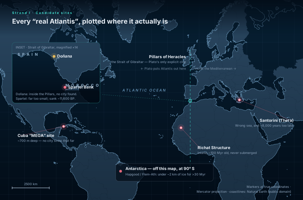
Map of the Atlantic and Mediterranean projected from Natural Earth data, with the Cuba site, the Richat Structure, Santorini, and — in a magnified inset of the Strait of Gibraltar — Doñana and Spartel Bank plotted at their real coordinates, against a dashed meridian marking the Pillars of Heracles. Natural Earth · projected
Every candidate, plotted where it actually is. The dashed line is the Strait of Gibraltar — the one piece of geography Plato states outright. Markers sit at true latitude and longitude on projected Natural Earth coastlines. Doñana and Spartel Bank are only ~120 km apart, so they get a magnified inset rather than two overlapping dots.

The one clue Plato gives you

Before scoring anything, look at the single geographic statement in the text. Atlantis lay beyond the Pillars of Heracles — outside this strait, in the open Atlantic. Almost every popular candidate sits inside it, or nowhere near it.

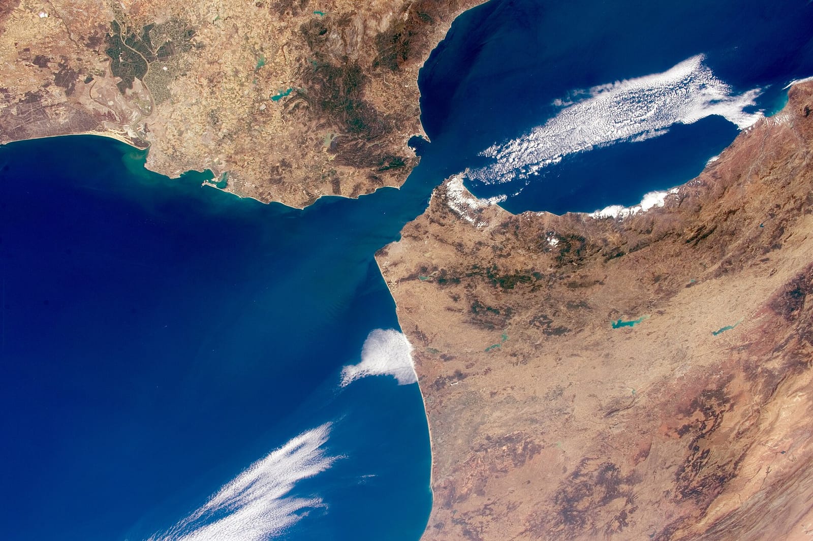
The Strait of Gibraltar photographed from the International Space Station: Spain and Morocco separated by a narrow channel joining the Mediterranean to the Atlantic. NASA · ISS Expedition 44
The Pillars of Heracles, from orbit. Spain to the north, Morocco to the south, and the 14-km gate between the Mediterranean and the Atlantic. Plato's Atlantis lay past this strait, in open ocean. Santorini is 2,400 km the wrong way; Doñana is inside; the Richat Structure is 600 km inland on the African continent. NASA/Scott Kelly · Public domain · source

The scorecard

Each site against Plato's four stated criteria. match · partial · fail.

Candidate Beyond Gibraltar~9600 BCEVast sea powerSank in the sea Verdict
Santorini / Thera Spyridon Marinatos; Galanopoulos & Bacon Speculative
Spartel Bank Jacques Collina-Girard Refuted
Doñana / Tartessos Rainer Kühne; Richard Freund Refuted
Richat Structure YouTube ("Bright Insight") et al. Refuted
Antarctica Charles Hapgood; Rand & Rose Flem-Ath Refuted

The candidates, one at a time — and what each place actually looks like

Four of the five can simply be looked at. Where a real photograph of the place exists, it is here: these are the actual sites, not reconstructions.

The Santorini caldera photographed from the International Space Station: a ring of cliffs enclosing a flooded basin, with the volcanic islets of Nea Kameni at its centre.

Santorini / Thera

Speculative

Proposed by Spyridon Marinatos; Galanopoulos & Bacon

The Late Bronze Age Minoan eruption was a real VEI-7 catastrophe that devastated a sea-trading culture — the closest thing to a historical kernel. But it is in the Aegean (not beyond Gibraltar), ~1600 BCE (not 9600), and far too small. Proponents must "divide Plato’s numbers by 10" to make it fit.

The caldera is real and the catastrophe was real — this is a flooded volcanic crater 12 km across, left by a VEI-7 eruption. What it is not is Atlantic, 9600 BCE, or continent-sized.

NASA · Public domain

No photograph exists — Spartel Bank is a drowned hill roughly 60 m below the Strait of Gibraltar, mapped by echo sounder rather than seen.

Spartel Bank

Refuted

Proposed by Jacques Collina-Girard

A real submerged paleo-island in the Strait of Gibraltar — at least it is in roughly the right place. But it submerged from slow sea-level rise ~11,600 years ago, not a sudden sinking, and is tiny. The "matches Plato" version was refuted in verification.

The Coto Doñana marshes in southern Spain after spring rain: flat, shallow wetland stretching to the horizon under an open sky.

Doñana / Tartessos

Refuted

Proposed by Rainer Kühne; Richard Freund

Marshland in southern Spain, near (but not beyond) Gibraltar, tied to the lost culture of Tartessos. National Geographic’s 2011 film amplified it — but the actual excavations found material dated to the Muslim period, and the project’s own anthropologist said no Atlantis was found.

A real wetland with a real lost culture attached to it — and a place you can simply walk across. The excavations here dated to the Muslim period.

Birding In Spain · CC BY-SA 4.0

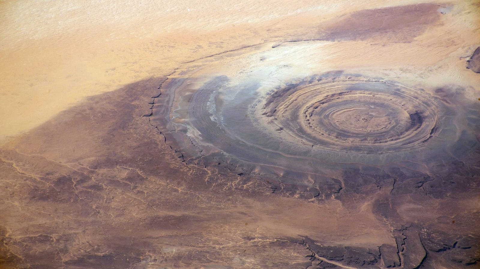
The Richat Structure in Mauritania from orbit: concentric rings of eroded rock surrounded by open Sahara.

Richat Structure

Refuted

Proposed by YouTube ("Bright Insight") et al.

The viral favorite: a circular "Eye of the Sahara." But it is a natural eroded dome of 94–104-million-year-old rock, ~40 km across, far inland in Mauritania, with no archaeology of a city. It is older than complex life on land, let alone civilization.

The circles are genuinely striking. They are also 500 km from the sea, ~40 km across, and made of rock about 100 million years old.

NASA · Public domain

Antarctica seen from orbit in an orthographic satellite composite: a white continent of ice centred on the South Pole.

Antarctica

Refuted

Proposed by Charles Hapgood; Rand & Rose Flem-Ath

Proposes the whole crust slipped, carrying a civilization to the South Pole. Plate tectonics provides no mechanism for such a rapid pole-shift, and there is no evidence of a sub-ice city. Pure fringe geology.

The proposal needs the crust itself to have slipped. Below this ice sheet — kilometres thick, and in place for tens of millions of years — there is no city.

Dave Pape · Public domain

Exhibit: the "Eye of the Sahara," as it really is

The Richat Structure is the candidate the internet loves most — and the easiest to settle, because we can simply look at it. This is a real NASA astronaut photograph (public domain). Those concentric rings are a 100-million-year-old eroded rock dome, hundreds of kilometres inland, with no archaeology of a city. It is geology, not masonry.

Astronaut photograph of the Richat Structure in Mauritania: concentric rings of eroded rock, tens of kilometres across, in the open Sahara. NASA · ISS Expedition 66
The Richat Structure (Mauritania) from the International Space Station. Its rings are differential erosion of an uplifted geologic dome — not city walls, not harbour rings. Look at what surrounds it: desert in every direction, ~500 km from the sea, with no harbour, no masonry and no archaeology of a city. The concentric shape is the entire resemblance, and the resemblance is the entire argument. NASA · Public domain · source

The verified evidence behind the verdicts

The scorecard summarizes; these are the sourced, tested claims underneath it.

Proven

The Santorini "date problem," quantified: ~1600 BCE, not 9600 BCE

Peer-reviewed dating pins the Minoan eruption to the mid-to-late 2nd millennium BCE — radiocarbon wiggle-matching of an olive branch buried in the ash gives 1627–1600 BCE; the only live dispute is 17th vs 16th century. That is ~8,000 years adrift from Plato’s ~9600 BCE. The "divide by 10" workaround (Galanopoulos) exists precisely because the real numbers don’t fit.

Verified 3-0. Anchors why the strongest candidate still fails.

Speculative

Santorini = Atlantis is the strongest candidate — yet still rejected

Marinatos proposed it and the BBC popularized it, but it fails on Plato’s date and location. Proponents Galanopoulos & Bacon conceded “the date of 9600 BC … is both incredible and impossible” and applied an ad hoc “divide by 10” fix — confirming rather than testing the hypothesis. Mainstream scholarship holds every site-identification fails.

Verified 3-0.

Refuted

Spartel Bank "matches Plato" — refuted

The claim that Spartel Bank is a paleo-island submerged ~11,600 years ago matching Plato did not survive verification. What is solid: the Gulf of Cádiz sees M8–9 earthquakes/tsunamis every ~1,500–2,000 years — a real mechanism, but it does not make Spartel into Atlantis.

Atlantis identification refuted 0-3; the underlying geology verified 3-0.

Refuted

Spartel Bank: the one site with the right date, killed by the seafloor itself

Jacques Collina-Girard (2001) noted Spartel Bank — a paleo-island beyond Gibraltar — submerged ~11,600 years ago, matching Plato’s date and "beyond the Pillars" location better than anything else. Then Marc-André Gutscher’s 2005 high-resolution multibeam survey (published in Geology) settled it: by that date the island was reduced to wave-swept islets under 500 m across (at most ~5×2 km after subsidence correction), with no man-made geometric structures. His verdict: any inhabitants "would have probably been simple fishermen and not a Bronze Age culture as described by Plato."

Verified 3-0 in the candidate-sites pass. The real Gulf of Cádiz earthquake/tsunami record (8 quakes in the turbidites) is genuine — the civilization is simply absent.

Refuted

Doñana / Tartessos (Freund) — undercut by his own team

Prof. Richard Freund claimed satellite-imaged structures in the Doñana marshes were tied to “Atlantis/Tarshish” (National Geographic’s 2011 Finding Atlantis). His own project’s anthropologist, Juan Villarías-Robles, said nothing exceeded expectations and items dated to the Muslim period — no Tartessos, no Atlantis.

Verified 3-0. Freund’s claims were criticized as overreach within the project.

Refuted

The Richat Structure ("Eye of the Sahara") is geologically impossible as a city

A natural eroded geological dome ~40 km across, formed by a subsurface igneous intrusion. Its rocks cooled 94–104 million years ago, it sits far inland (contradicting Plato’s maritime power), and there is no archaeological evidence of any city. The YouTube “Richat = Atlantis” thesis is fringe pseudoscience.

Verified 3-0.

Proven

The Richat Structure is natural geology — NASA imagery shows why

The "Eye of the Sahara," made famous as Atlantis by YouTube channels, is an uplifted, deeply eroded geologic dome of sedimentary and igneous rock — its concentric rings are differential erosion, not city walls. NASA Earth Observatory documents its geology, and NASA/ISS satellite photography of it is public domain. The real photograph is the rebuttal.

Geology corroborated by NASA Earth Observatory; image is public domain (shown on this site).

What might have really inspired Plato

Rejecting the candidates doesn't mean Plato invented in a vacuum. Two real events sit close enough to have seeded the imagery — a city that genuinely sank in his lifetime, and a prehistoric flood. These are the honest "kernels of truth": inspirations, not Atlantis.

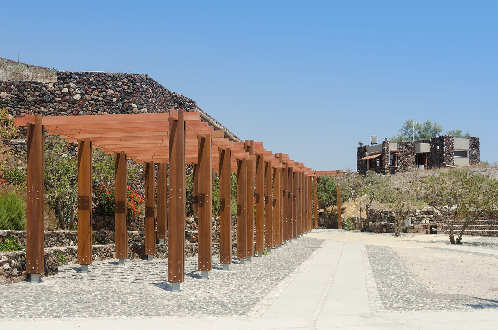
Excavated streets and multi-storey stone buildings at Akrotiri on Santorini, sheltered under a modern roof, preserved by volcanic ash. Akrotiri, Santorini
Akrotiri: a real Bronze Age town, buried by a real eruption, and dug out again. Streets, drains, staircases, three-storey houses. This is what an actual advanced maritime settlement destroyed by catastrophe looks like when you find one — mundane, specific, and covered in ash. It is the closest thing to Atlantis that exists, and it is nothing like Plato's description. Norbert Nagel · CC BY-SA 3.0 · licence · source
The Ship Procession fresco from Akrotiri: a long painted frieze of oared ships with decorated sterns moving between two coastal towns. ~1600 BCE · wall painting
The Ship Procession fresco from the same site — a fleet, painted by the people who sailed it. A wealthy sea power, wiped out by a volcano, within cultural memory of the Greek world. That is a plausible seed for a story about a maritime empire lost to the sea. It is not a lost continent in the Atlantic. Public domain · source
Speculative

Helike: a real city that sank in 373 BCE — a likely inspiration

Helike was a Greek city in Achaea destroyed and submerged by an earthquake and tsunami in 373 BCE — a single night, beneath the sea, within Plato’s own lifetime and just before he wrote. It is a documented historical event and a plausible real-world seed for Atlantis’s "single day and night" destruction motif. This is inspiration, not identification.

The sinking of Helike is PROVEN history; the link to Atlantis is reasoned but speculative.

Speculative

The Black Sea deluge: a real flood, a contested magnitude

Ryan & Pitman (1997) proposed that ~7,600 years ago Mediterranean water breached the Bosporus and catastrophically refilled the Black Sea — a candidate source for ancient flood myths. Newer Danube-delta stratigraphy (Giosan et al.) suggests the pre-reconnection lake stood much higher than the dramatic version requires, so the catastrophe’s scale is genuinely disputed. At most a flood-myth inspiration, not Atlantis.

A real reconnection occurred; its catastrophic magnitude is contested in the literature.